Wednesday, February 24, 2016

Anything Can Happen!

Macrina was a 4th century Greek mystic and visionary who
started a community that emphasized a simple, self-sufficient lifestyle.
Recently a friend invited me to spend an 'anything can happen day' with her in Seattle, Washington. I immediately accepted, unaware that I was about to learn that ‘anything can happen’ is characteristic of Seattle culture. Our first stop of the day was Macrina Bakery and Café at their SODO location on First Avenue South. We had an 11:00 appointment for a tour.

Marina Bakery and Cafe

Macrina Fruit Babka Bread
As we waited in the café of their LEED certified building for the Wholesale Sales Manager to arrive, I stared through big glass windows into the bakery. Over a dozen Vietnamese workers were forming individual bread rolls. Macrina is an artisan bakery in which every item is hand-formed and freshly baked. Translate that to mean it is labor intensive!

The yummy pastries and lunch menu items defy description.
Upon her arrival our guide gave us a brief history of Macrina, beginning with founder Leslie Mackie’s vision of bread as a connective tissue for local communities - as it was and is in places like France and Italy.
Founder Leslie Mackie is fond of anything 'natural'.
Mackie is an internationally renowned chef and baker. It is totally remarkable that in expanding from one bakery and café to three, she and four owners have been able to maintain the basic commitment to hand-formed and freshly baked bread and pastry. They even have an Italian clay brick oven. When purchased, an Italian artisan came to Seattle to install it properly.

Imagine hiring a woman just to remove Rosemary from twigs.
That shows commitment to hand-formed and freshly baked bread and pastry!
I asked about the Vietnamese workers and learned that because of Vietnam’s French connection, people there are familiar with artisan baking. Ok, but how many companies do you know that offer English As A Second Language to their workers and encourage them to speak English in the work place so the lessons will take?

Sip and Ship


Sip and Ship is a local business in Ballard and Greenwood/Phinney Ridge areas.
If I was overwhelmed by how local company Macrina Bakery maintains it's core values, the innovative concept at our next stop, a Sip and Ship business on NW Market Street, took my imagination to yet another level. 

Chairs out in front encourage the feeling of a neighborhood node.
What a business concept: your personal mailbox located where you can receive packages, sit and read your mail with a cup of coffee and a snack or you can buy a gift, have it wrapped and shipped all in one place.

Don't you love the sliding ladder?
Old library concepts have new life in today's world.
With two Seattle locations (Ballard and Greenwood/Phinney Ridge), this innovative little business has won a number of awards.

Did you know that candles are the #1 gift item worldwide?
Can you believe I found a jar of Kale and Parmesan Pesto in their gift area? The friendly site manager is from Atlanta and has introduced some new gift items. Although cards, candles, and bath accoutrements were tempting, the pesto was my one purchase of the day.

Fountainhead Gallery

As a 'lover of light' Fountainhead Gallery won my heart immediately.
And then ... a real treat for this artist ... we landed at the Fountainhead Gallery on quiet but quirky McGraw Street on Queen Anne hill. While I enjoyed the hustle and bustle of our first two stops, I welcomed the serenity and spaciousness of this sophisticated gallery.

A staircase to the second level provides a view of the entire space.
We were welcomed by the Gallery Assistant who gave us a first class tour. I loved how even the storage area walls were filled with lovely art, adding to the gallery space, providing a feeling of openness, and an awareness that art belongs in every room.

What gallery do you know that has a mini stage that is perfect
for intimate musical performances?
In addition to the upbeat atmosphere created by light streaming in through storefront windows and skylights, the gallery has a small stage that makes musical events a snap. In addition they make use of a lovely table in front of an inviting heating stove for book signings.

This gallery knows its audience and enriches their lives in a variety of ways.
Displaying regional and local artworks for twenty years, Fountainhead Gallery understands customers want a variety of cultural events as well as a chance to meet artists. All of the arts support and feed each other and people today seek participation and interaction as well as an opportunity to view good visual art.

The open floor plan allows for multiple space configurations.
Located on a precious corner spot near neighborhood businesses and an elementary school in a close knit community, this gallery is situated to grow into a neighborhood cultural center with an ongoing series of musical events, artist demonstrations, and art workshops to accompany its beautifully displayed art. Need I mention there’s a Macrina bakery and café just down the street?


My hostess and event planner was Leah Early (left). 
Clearly in Seattle, anything can happen, and does! Whether it’s Microsoft, Macrina Bakery, Sip and Ship, or Fountainhead Gallery, the entrepreneurial spirit is alive and well in this Northwest city.

For those of you who know Leah and Lee Early, it will not surprise you that the Wholesale Sales Manager of Macrina Bakery is daughter Rebecca Early, Co-owner of Sip And Ship is Diana Early Naramore, and Fountainhead Gallery Assistant is Laura Early. With a father who is a business consultant and a mother who is a former speech and debate coach, these entrepreneurial women had a leg up on making a splash in Seattle.

When was the last time you had an ‘Anything Can Happen’ day?


Photo Credits
Macrina Bakery: #2, 4 Macrina Bakery website: #1, 3, 5 LiDoña Wagner
Sip and Ship: LiDoña Wagner
Fountainhead Gallery: #2, 3, 4, 5 Fountainhead Gallery Facebook page: #1 LiDoña Wagner
Leah and LiDoña: Ballard Sip and Ship location manager

Tuesday, January 26, 2016

Mission Accomplished (Almost)

One of my 2015 goals was to complete both the Southeast Asia and Southwest Asia sections of Eve’s Imprint. I had been working on SEA since 2012 when I still held a full-time job. In 2014 during my residency in Italy I digressed to paint a volcanic eruptions banner, the largest single piece I have ever done. At the beginning of 2015 I was primed to return to my work on Southeast Asia and bring it to completion. It was not as hard as I’d anticipated and culminated with creation of the Ecosystems stick map in February.

So I moved on to Southwest Asia and was rolling along nicely until I had a fall at the end of August in which I broke my right hand and injured my left shoulder. These injuries brought my painting to a halt for about six weeks and then I had to work slowly for a while. I pretty much kept quiet about this fall because I am embarrassed about being such a klutz.

As the end of 2015 approached, I was determined to finish Southwest Asia, so I worked through the holidays, completing the pieces I'd envisioned on January 31st - New Year’s Eve day.

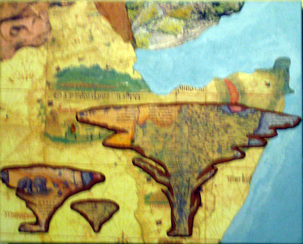
The southern end of the Red Sea shown as it enters the Gulf of Aden
at the northern coast of the Horn of Africa.


Genetic scientists believe that Homo sapiens left Africa by crossing the Straits of Grief at the southern end of the Red Sea 70,000 to 60,000 years ago. In other words, the horn of Africa (Somalia, Eritrea, and Ethiopia) was our jumping off point for the maiden migration of Homo sapiens out of Africa into the unknown wilderness beyond.

Stephen Oppenheimer, a British scientist whose studies form a large portion of the 2003 discovery channel video, The Real Eve, opines that eating fish accelerated the growth of both the human brain and the human population. He says that perhaps the fish supply was strained by this population growth and prompted people to look across the Straits of Grief and long for the ‘green hills of Yemen’.

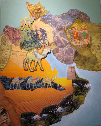
The grid images on the left side of Arabia and to the right of Iran are
from an Islamic map created in the middle Ages. The writing in the grid
gives the coordinates of geographic locations, to be used in determining
the direction of Mecca for prayers.
The Arabian Peninsula was not always desert. Apparently it has oscillated between fertility and desert more than once. Those migrants who survived the crossing of the Straits of Grief landed in a botanical garden. Some of these original migrants stayed in present day Yemen and after a time - as they multiplied - migrated north by land. At least an adventurous few continued by water along the coast, arriving in present day Iran.
On the left is Iran and on the right are Pakistan and Afghanistan.
The battle from the backs of elephants is a transfer of cave art.
Most likely some of those migrants, upon touching the shores of Eurasia, were captivated by the river-fed lands they gazed upon and decided to stay. The fertility of the land aided their population expansion and they followed both rivers and land further inland and within 10,000 years, many had settled in Mesopotamia (present day Iraq).

Once again, there were those migrants who preferred a maritime existence and they continued along the coast of present-day Pakistan. As they sailed, they dropped off a few of their number in various places. Perhaps there were pregnant women or small children who needed to stop for a while. And of course, as we all know, once you have paused and found a hospitable place that nurtures body and soul, why would you return to an itinerate life? Some of these coastal people eventually made their way north into the Indus River Valley where they created a culture that rivaled that of Mesopotamia. Others continued north into present-day Afghanistan. 

The tiles at the top are to indicate the height of the Himalayas
and how they formed a barrier to Asia. The map in the lower right
shows DNA mapping of migrations.
At least an intrepid few adventurers continued along and around the vast coastline of the Indian subcontinent. There they found fertile land, inviting caves, and the majestic and ferocious Bengal Tiger. It would have been a courageous covey of migrants who decided to enter a land ruled by tigers, elephants, and other dangerous animals. For whatever reasons, some migrants did indeed stay and before the beginning of the first millennium of the current era, some had reached the Bhimbetka caves in central India and inscribed their understanding of life on the cave walls. Most of my India and Pakistan cave art images are from these caves. Remember, until the mid 1940s, Pakistan and India were one country.

Other migrants found their way by water to the islands known today as the Maldives, the large island known today as Sri Lanka, and further to today’s Nicobar and Andaman islands. A goodly portion of these maritime migrants continued on into Southeast Asia.

Once I had my tiger and tiles done, I had to do a make-over
on the Nicobar Islands at the lower right.
I had a friend join me on New Year’s Eve and after viewing the newly completed Southwest Asia panels, she spotted the Southeast Asian Ecosystems Stick Map. She immediately pronounced, “You have to do a three-dimensional piece for Southwest Asia.” As soon as she said it, I knew she was right; I guess I didn't quite make my deadline after all.

We brainstormed how these adventurous migrants would have navigated from one place to another. In prehistoric times Homo sapiens were keen observers of natural and celestial patterns and gradually created navigation tools to help travelers make their way through distant lands and seas. I did some research and found that by the time of the Greeks an instrument called an astrolabe had been invented. Later I will tell you more about that and the 3D piece I now envision for Southwest Asia.

I apologize for the poor quality of my photographs. They do not reflect the sizes of the pieces: In inches, Horn of Africa is 10 x 8, Arabia/Iran is 16 x 20, Iran/Pakistan is 6 x 12, India is 18 x 24 and the islands are 4 x 6, except Sri Lanka is 4 x 4.

Saturday, December 19, 2015

A Season for Contemplative Action

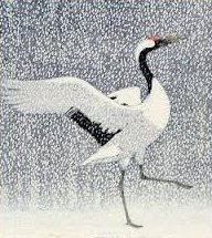
Japanese Crane 
Here in the northern hemisphere, Winter Solstice approaches like the whispering sound of bird wings. Soon we will teeter on the edge - the shortest day and longest night  - before falling into the infinity of returning light. Winter Solstice is my favorite holiday because I am in love with light and the silent moment by moment increase of light fills me with hope precisely when I need it most – during the cold and darkness of winter.

Moreover, the solstice is that moment in time when the opposites are held in tension: light and dark, long and short, winter in the northern hemisphere and summer in the southern hemisphere, youth and age. Each has a unique energy. It reminds me, a lover of light and of uplifting experiences, that life is about holding the opposites in the sort of dynamic balance one sees in certain Japanese prints.

For a quarter of a century I have been celebrating a ritual of 12 Days of Christmas – a time of gifts of self affirmation as I celebrate the divine child within each of us. This year the season of the solstice has announced itself differently, calling me to celebrate a Season of Contemplative Action.

Freedom of Religion is protected by
the US Bill of Rights.
A Season of Contemplative Action
I heard this call when a certain self-proclaimed demigod and presidential candidate denied a fundamental underpinning of American democracy – the right of religious freedom. The first European pilgrims to the shores of North America came because they sought freedom from religious persecution. Thus they enshrined religious freedom in our Bill of Rights.

When I read that this man - I refuse to lend energy to him by even saying or writing his name - is advocating the exclusion of Muslims from our multi-cultural society, I said, “Maybe I should retire to a contemplative convent and pray for the souls of such deranged fear mongers.”

Then I realized that as a solitary person, I already live in a place of contemplation. I do not need to go somewhere else to perform acts of contrition. Thus began the making of lists for a season of contemplative action.

Photo from Central Asia Institute's Pennies for Peace.
The education of girls is the surest road to peace.
12 Life Affirming Acts
Honoring others with gifts of gratitude for their presence in my life and for the gift of life on earth

Probably because I have had a gratitude practice for a number of years, it is fairly easy to see the small acts I can do to honor nature, my neighbors, my family, my friends, and benevolent organizations such as Central Asia Institute and The Malala Fund. Many of these acts - such as feeding the birds, caring for a public garden, and putting up lights that my neighbors can enjoy - give me joy as well.

12 Calls to Turn My Life Around
 Standing present to my shortcomings

Acknowledging my personal transgressions is a difficult list to face. Clearly I harbor harsh feelings toward political reactionaries and fundamentalist religious fanatics. Though I know better, I still pollute my body with sugar and dairy products, by not drinking enough water, and not eating enough green leafy vegetables. I have a terrible habit of having my head in the clouds when I walk, leading to four falls in the past decade. Not to mention my lack of patience with rule-bound ‘service’ providers and institutional bean counters. Many of you could provide me with more suggestions for how I can become a better member of the human Community!

Photo from Central Asia Institute's Pennies for Peace 
program in which elementary children collect pennies
and send them to help girls receive an education.
12 Calls for Intercession
Dedication to the alleviation of suffering near and far  

Your list of places, people and issues that require attention and care would no doubt be slightly different than mine. But perhaps we can agree that it was heartening that 195 nations around the world signed the Paris Accord, committing to reduce the amount of carbon with which we are polluting planet earth. Having Russia, Syria, United States, Arabia, and Iran agree to look for middle ground for ending the civil war in Syria is certainly a welcome sign toward peace on earth.

What would be on your lists? During this time in which darkness submits to light may each of us contribute to ...

Peace on Earth

Good Will Toward All


Tuesday, November 24, 2015

A Sense of Inevitability

The earliest known illustration of the Silk Road. A caravan is crossing the desert
of Chinese Turkistan, the camels laden and the merchants on horseback.
This is from the Catalan Atlas, a Spanish illuminated world map prepared in 1375.
When we listen to an enthralling symphony or see an inspiring piece of visual art, we have a sense of inevitability about these creative expressions. They could not be otherwise than as we experience them in the moment. In fact what we experience was not inevitable but is rather the result of a composer or artist being willing to take an arduous and even torturous path of trial and error.

In the eight-year process of developing his inevitable sounding fifth symphony, Beethoven produced 17 sketches for one section alone. From these he chose the one he felt worked best. He also created three different endings. He thought his first draft of the ending was too brief. So he did a longer version. That did not work either. But it convinced him that the problem with his initial short version was that it was too long! So he created an even shorter ending, the one that we hear today.

Persia Today

Laying out possible images for use on the Iran part of
the Southwest Asia alcove of Eve's Imprint.
A couple of weeks ago I began working on the Arabia and Iran section of the Southwest Asia alcove of Eve’s Imprint. I posted that moment on my newly created Facebook page. The Arabia and Iran section will hang to the left of the India and Pakistan section I began several months ago. Remember my tiger? For Iran, I had located maps, pottery sherds, and rock art.

Iran is a remnant of the vast Persian empire that once covered most of the Middle East as well as parts of India and Central Asia. The geographic region of present day Iran was one of the first stops after Arabia as our ancestors migrated out of Africa. Its rock art goes back to Paleolithic times. For me the pottery sherds represent the Neolithic revolution of agricultural settlements. Right next to Mesopotamia, Iran played a role in the spread of agriculture to Eurasia. During the middle ages, Iran was an important way station along the extensive Silk Road, resulting in the spread of Zoroastrianism which has several contemporary derivatives.

The Technique of Image Transfers

A page from LiDona's Book of Errors showing two of my
transfer experiments.
Because I want Iran to have a sense of fragility, I decided to use transfers of my selected images. However, my first attempt to transfer a map fragment showing a Silk Road caravan was only mildly successful and I ended up scrubbing it out. This experience led me to pull out LiDoña’s Book of Errors, a sketchbook in which I recorded a series of experiments.

Materials used for transfers.
Reviewing my transfer experiments helped me recall critical aspects:
  • type of medium - Extra Heavy Gel works best
  • size of the piece being transferred - smaller - about 3” x 3” – rather than larger allows greater control in assuring complete contact between the image and the gelled surface
  • type of brush for applying gel - an old bristle brush with lots of broken ends seems to work best
  • amount of gel applied - a liberal amount applied to both the surface receiving the transfer and the image being transferred
  • how to insure complete contact - cover the image with a paper towel and brayer over it
  • how the process sets up - a wet cloth over the transfer enables the transfer of the ink into the gel
  • how long it needs to dry once the cloth is removed - until the paper is completely dry
  • how best to remove the paper on which the image is printed - a slightly wet toothbrush does the heavy lifting and rubbing one’s fingers removes the remaining fuzz. 

So I made a new attempt. This time I did two small transfers – images of two Iranian pottery sherds.


I love the soft green in these two potter sherds.

Now the Fun Begins

These were more successful so I decided to cut my Silk Road Caravan in half to have smaller pieces with which to work. In doing so I decided to eliminate the Chinese-looking men behind the camels.

A transfer gives a mirror image. Look at the caravan above
to see how these camels were headed originally.
The transfer of the camel half of the image came out pretty well, but the half with the horses did not work. Even following optimum procedures, sometimes the magic works, and sometimes it doesn’t! As I reviewed my results, it occurred to me that I would like for the camels and the horses to be headed in different directions. What if the camels appeared to be coming from Arabia and the horses appeared to be coming from India and China?
Although I wanted a fragile look, this was a
bit more than I was looking for.
I decided to paint over my transfers and make another attempt. Luckily, I had made several copies of the Caravan in slightly different sizes since I wasn’t sure what I would need. I decided to have the transfer of the camels image touch not just Iran, but also Arabia and Iraq, the teal area that I will include in the Near East alcove of Eve’s Imprint. I really liked this result.

I like the way the teal surface under the left part of the transfer
creates a soft green similar to that in the pottery sherds.
I should mention that when you do transfers, they appear in reverse of the image you are transferring. In order to visualize what I will get with the transfers, I use a tracing of my basic composition. By reversing the tracing paper and placing my images underneath, I am able to get some idea of the result I’m going to get. This is especially crucial the further you go since there is less space with which to work.
In the Iran section, you can see that I drew around the
transfers that had already been done so I could tell where
to put the rock art.

Changing Direction

In order to get my horses going in the opposite direction, I scanned a smaller version of the Caravan image, took it into PhotoShop, and flipped the image horizontally. When I printed out the flipped image on my home printer, it appeared too light to transfer well. So I opened it in Preview where I discovered that I could do several of the things that I normally use PhotoShop to do, including color saturation. For good or ill, I now had an image that was slightly different in size and in color tones from the one I used for the camels.
You can see the Chinese men I eliminated behind the camels.  
Using the tracing paper to help me with placement, I decided to have the horses transfer overlap the lower pottery sherd and Pakistani rock art.

Remember that with the transfer my horses are now going
in the other direction.

Hodgepodge of Images

Next I turned to transfers of Iranian rock art. Using the tracing paper composition was essential in placing these transfers. You can see that for now Iran is a hodgepodge of images. I don’t think I’ve done 17 sketches yet, but I may well go beyond that before this area is resolved. Before I can tell what is needed to bring Iran together I need to go on to Arabia and the Horn of Africa.

A rock art human now stands between the camels and the horses.
I don't care for the yellow behind the horses so I will have to
figure out how I'm going to change it.
In speaking of the number of materials he tried for producing electricity, Thomas Edison said, I have not failed. I've just found 10,000 ways that won't work. Who knows? It may take 10,000 attempts to get the Southwest Asian alcove of Eve’s Imprint to the coveted sense of inevitability.

Friday, October 30, 2015

Love Is Blind


Red lines show female migration routes from tracing mitochondrial DNA.
Blue lines show male migration routes from tracing the male chromosome.

Our Maiden Migrations

Following the first human migrations across the southern end of the Red Sea about 75,000 years ago, some of our ancestors settled in Yemen which at that time was greener than it is today. Others sailed on along the coasts and again, some people settled on the east coast of the Arabian Peninsula while others sailed on to the Persian Gulf.

I don’t know how many generations these migrations took, but there was a continuous pattern of both settlement and further travel: those who stayed and those who moved on. The settlers inhabited the land adjacent to the coastline and began venturing inland. The travelers sailing along the coastline reached what is now Pakistan, India and India’s neighboring islands. From there they went on to Southeast Asia. No one knows what navigation tools beyond the stars and oral history were available to those who first took to the sea.

Islands As Steppingstones

Many generations passed and the ice age had to end before Europe and Asia were reached. As populations expanded, islands such as Ceylon just southeast of the tip of India and the Nicobar islands farther to the southeast became trading crossroads. Others such as the Maldives to the southwest and the Andaman to the southeast were sparsely settled and remained quite wild. In creating the pieces for the Southwest Asia alcove of Eve’s Imprint, I decided that including the islands would help people grasp the waterborne nature of these first ancestral migrations. 
Map of Sulawesi serves as cover of Mapping the Silk Road and Beyond. 
Because I’m in love with the maps in Mapping the Silk Road and Beyond and the multiple and changing perceptions they reflect, I decided to use a variety of maps on the island panels surrounding India. The maps can be confusing because there was no standard orientation. Some early map makers put east at the top, some put south, and some put west. Many mapmakers used the ocean and sea areas on their maps for depictions of the objects being traded. Others emphasized the boats and ships carrying trade goods. Still other mapmakers pictured the winds that were critical for boats to move.

I’m sure that during the Middle Ages when these maps were made there were farmers in the fields of Europe, the Near East, and China who did not know of the existence of these maps and the new worldview they presented. Most people went about their lives as they always had, some believing the earth sat on the back of a large turtle and others that at a certain point ships would fall off the edge of what they perceived as a flat earth. But for traders, sailors, and an educated elite these new art forms were as provocative as Paleolithic cave paintings had been for people of that era.

I worked first on the island of Ceylon, contemporary Sri Lanka, using a map that depicted products and landscape. The colors went well with the shaded part of my tiger (map of Goa). Sri Lanka has a beautiful tear shape that appeals to me and I wanted to emphasize that so I blew up the map to make it fill the 4” x 4” panel. 

The later addition of a blue river, an elephant, and a touch of green from the Sulawesi
map, linked this panel to the one to its right and brought this panel to life. 
To give the panel some dimensionality, I took another smaller map of Ceylon and placed it on top of the blown up one. I knew the composition was too “flat” but I left it while I worked on the others.

I spent a lot of time finding maps and images of the Maldives, a series of small islands to the southwest of India that are disappearing as a result of climate change. After several compositions came and went, I decided to use a blowup of one map as a base and to cut out pieces from a lower scale blowup of another map to put on top of the monster map.

Rising water due to climate change is covering
the Maldives. I wanted this 4"x 6" panel to suggest the
beauty and cultural diversity that are being lost.
I found a tiny snapshot of a traditional Maldivian boat sailing on the Indian Ocean. I really liked the graceful shape of the boat and the sail that mirrored the tear shape of Ceylon (Sri Lanka). I blew that snapshot up 800% to get the boat to be the size I wanted. I debated about using a tracing of the boat or drawing and painting it, but decided against those ideas. The base map for the Maldives blends nicely with colors in my India tiger.   

To the east of India and lying along the coast of Burma (Myanmar) and Malaysia are the Andaman and Nicobar Islands. They may have been part of what were called the East Indies; that’s a guess, I really don’t know. Early mapmakers were confused about where one set of islands ended and the next ones began. I found three maps that I liked and decided to use all three on this panel, one on top of the other. The base map is the same one that served as the base for my India tiger.

The pale map with colored edges shows the coastline best
while I liked the drawing of the islands (pink) from another map best.

Letting Nonessentials Go

Since the Nicobar Islands were a steppingstone to the riches found on the islands of Indonesia, I allowed my love for the map cover of Mapping the Silk Road and Beyond to get the better of me. The book's cover is a map of Sumatra that is oriented with west at the top. It represents the battles fought between indigenous people and greedy European traders.

Even though I loved everything on this panel,
you can see how busy and lacking in cohesion this was.
I took the most dramatic section of the map as my base for the Nicobar panel and glued cut outs from a map of the Nicobar Islands on top of it. I added European ships from elsewhere on the map to show the conflict. However, once I put that panel in place I could see that it was totally competing with everything else, including my tiger. There were too many queens and too few commoners. 

I tried some minor adjustments, such as covering one of the two very dramatic elephants. That didn’t work, however it gave me the idea of adding a lower scale section of the river and one of the elephants to the Ceylon (Sri Lanka) panel to tie it to the Nicobar panel. Ships often stopped in Ceylon (Sri Lanka) before and after trading in Sulawesi (Indonesia). This added the dimensionality that I had felt this panel lacked.
After making my sketch, I saw immediately that the second ship
to the left was too much and eliminated it.
I decided it was the whole lower section of the Nicobar panel that needed to go. I traced that section and used the tracing to cut out sections from the book cover map and from two other maps. 

As much as I loved this section from the book's cover, I could
see that it did not fit with the other island panels or my tiger panel.
I tried using a section of one of the maps I used for the Andaman
Islands. That didn't work but it gave me the idea of using a
section from the base map on the Andaman panel.
The colors in this map brought the Andaman and Nicobar panels
together and were more in keeping with my tiger.
At the top of the panel, I changed the size of the Nicobar header and
added more of the Anbdaman base map to cover competing colors and shapes.
On an artistic level, the island panels need to integrate with each other and the larger surrounding panels. Therefore, I added a couple of ships to the Andaman panel to connect it with the Nicobar panel below. Over and over as I worked on these island panels, I had to confess that love is blind. Things that I loved on their own did not work in relation to each other.

Many refinements are needed on these small island compositions. But for now, I am ready to leave the islands as they are and go on to the Arabian and Persian sections of Southwest Asia. Only when I have the total configuration of panels will I be able to see what other changes are necessary for the islands to complement and not compete with the major panels.