
So I moved on to Southwest Asia and was rolling along nicely
until I had a fall at the end of August in which I broke my right hand and
injured my left shoulder. These injuries brought my painting to a halt for
about six weeks and then I had to work slowly for a while. I pretty much
kept quiet about this fall because I am embarrassed about being such a klutz.
As the end of 2015 approached, I was determined to finish
Southwest Asia, so I worked through the holidays, completing the pieces I'd envisioned on January 31st - New Year’s Eve day.
Genetic scientists believe that Homo sapiens left Africa by
crossing the Straits of Grief at the southern end of the Red Sea 70,000 to
60,000 years ago. In other words, the horn of Africa (Somalia, Eritrea, and
Ethiopia) was our jumping off point for the maiden migration of Homo sapiens
out of Africa into the unknown wilderness beyond.
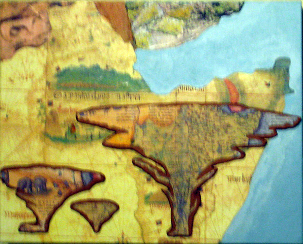 | ||||
| The southern end of the Red Sea shown as it enters the Gulf of Aden at the northern coast of the Horn of Africa. |
Stephen Oppenheimer, a British scientist whose studies form
a large portion of the 2003 discovery channel video, The Real Eve, opines that eating fish accelerated the growth of
both the human brain and the human population. He says that perhaps the fish
supply was strained by this population growth and prompted people to look
across the Straits of Grief and long for the ‘green hills of Yemen’.
 |
| The grid images on the left side of Arabia and to the right of Iran are from an Islamic map created in the middle Ages. The writing in the grid gives the coordinates of geographic locations, to be used in determining the direction of Mecca for prayers. |
The Arabian Peninsula was not always desert. Apparently it
has oscillated between fertility and desert more than once. Those migrants who
survived the crossing of the Straits of Grief landed in a botanical garden.
Some of these original migrants stayed in present day Yemen and after a time - as
they multiplied - migrated north by land. At least an adventurous few continued
by water along the coast, arriving in present day Iran.
Most likely some of those migrants, upon touching the shores
of Eurasia, were captivated by the river-fed lands they gazed upon and decided
to stay. The fertility of the land aided their population expansion and they
followed both rivers and land further inland and within 10,000 years, many had settled in Mesopotamia (present day
Iraq).
 |
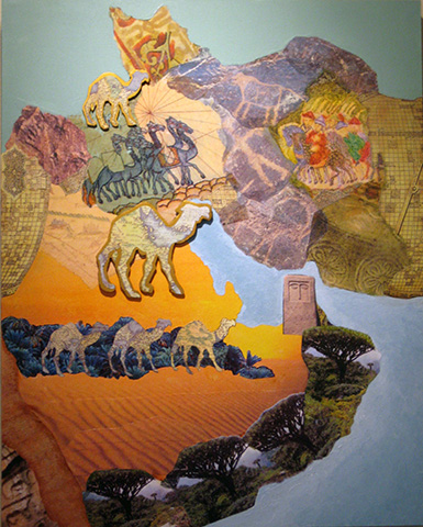
| On the left is Iran and on the right are Pakistan and Afghanistan. The battle from the backs of elephants is a transfer of cave art. |
Once again, there were those migrants who preferred a
maritime existence and they continued along the coast of present-day Pakistan. As they sailed, they dropped off a few of their number in various places. Perhaps there were pregnant women or small
children who needed to stop for a while. And of course, as we all know, once
you have paused and found a hospitable place that nurtures body and soul, why
would you return to an itinerate life? Some of these coastal people eventually
made their way north into the Indus River Valley where they created a culture
that rivaled that of Mesopotamia. Others continued north into present-day
Afghanistan.
 |
| The tiles at the top are to indicate the height of the Himalayas and how they formed a barrier to Asia. The map in the lower right shows DNA mapping of migrations. |
Other migrants found their way by water to the islands known today as the Maldives, the large island known today as Sri Lanka, and further to today’s Nicobar and Andaman islands. A goodly portion of these maritime migrants continued on into Southeast Asia.
 |
| Once I had my tiger and tiles done, I had to do a make-over on the Nicobar Islands at the lower right. |
We brainstormed how these adventurous migrants would have navigated from one place to another. In prehistoric times Homo sapiens were keen observers of natural and celestial patterns and gradually created navigation tools to help travelers make their way through distant lands and seas. I did some research and found that by the time of the Greeks an instrument called an astrolabe had been invented. Later I will tell you more about that and the 3D piece I now envision for Southwest Asia.
I apologize for the poor quality of my photographs. They do not reflect the sizes of the pieces: In inches, Horn of Africa is 10 x 8, Arabia/Iran is 16 x 20, Iran/Pakistan is 6 x 12, India is 18 x 24 and the islands are 4 x 6, except Sri Lanka is 4 x 4.
